Deglacial ice sheet dynamics

Geologic data provide crucial insights into Antarctic Ice Sheet dynamics. For example, glacial landforms imprinted on the seafloor mark the ‘footprint’ of marine-based ice sheets larger than today. On land, progressive exposure of mountain peaks emerging from the ice sheet reveal past ice elevation changes. My research analyzes geologic datasets and uses numerical ice sheet simulations to link these marine and terrestrial geologic records in space and time to make larger-scale inferences about continent-wide ice sheet evolution.

Ross Sea dynamics from landforms and ice-sheet modeling

During the Last Glacial Maximum, ~20,000 years ago, the Antarctic Ice Sheet was much larger and thicker than today, and extended to the continental shelf break in many places before receding to the modern configuration. Glacial landforms and sediments associated with ice advance and retreat are preserved on the seafloor. These features tell us that within the Ross Sea, ice-sheet retreat was influenced by regional topography and seafloor geology (Halberstadt et al., 2016), as well as subglacial meltwater (Simkins et al., 2017) and properties of the unconsolidated sediment underlying ice streams (Halberstadt et al., 2018).

...
...

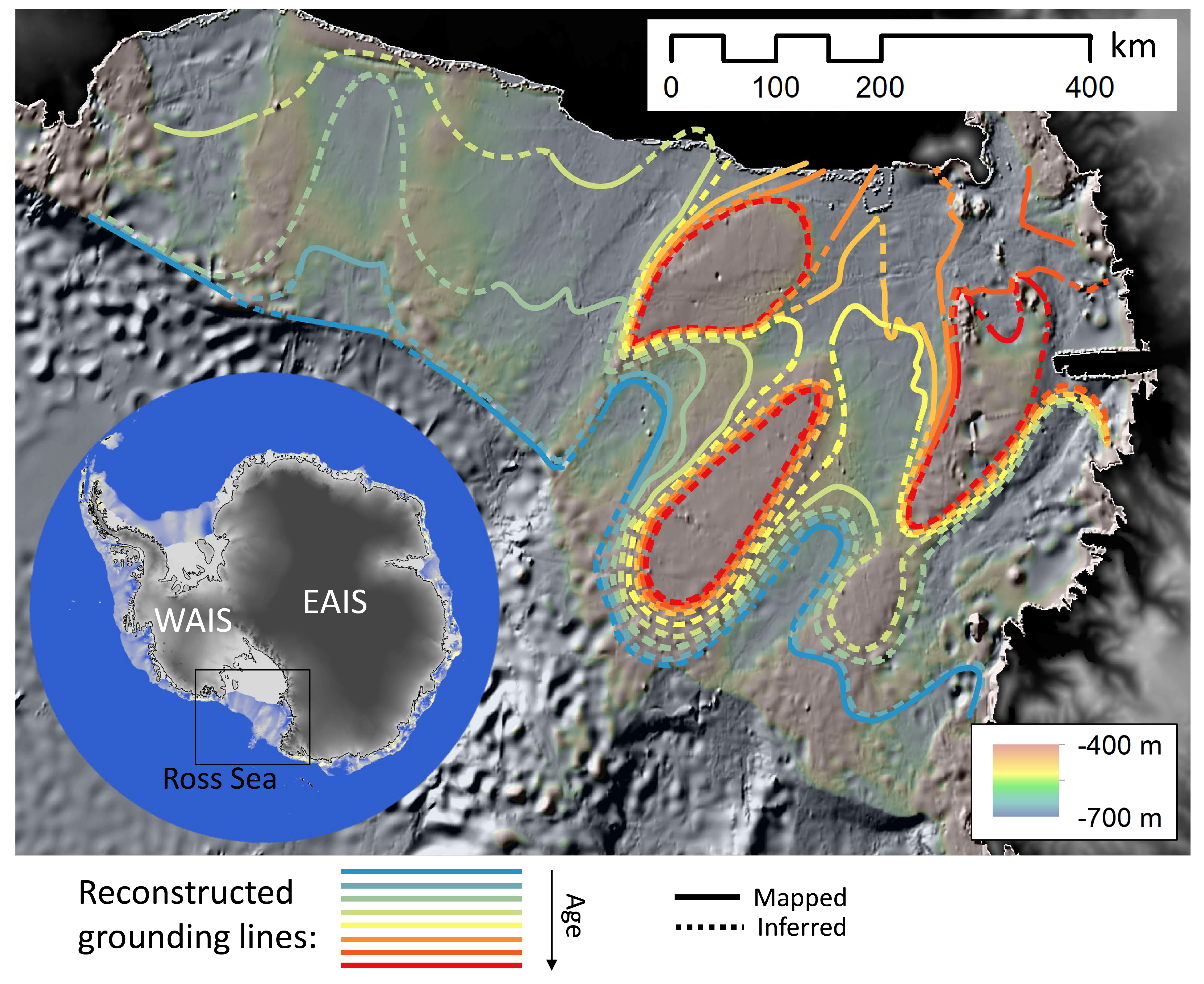
Retreat patterns of the Antarctic Ice Sheet based on seafloor landforms that record behavior of the grounding line, the point at which grounded ice transitions to a floating ice shelf. Each line marks a relative step in grounding-line retreat, starting with the Last Glacial Maximum (blue) and ending with ice pinned on banks (red). Prothro et al. (2020) use radiocarbon dating of seafloor sediments to establish the ages of these grounding-line positions.

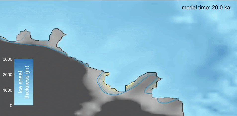
Numerical ice-sheet modeling can link these reconstructions of ice-sheet retreat with the physical mechanisms that influence glacial behavior. This video shows how the grounding line fluctuates and eventually retreats throughout the last deglaciation (ice shelves are not shown here).

Read more about Ross Sea deglacial dynamics reconstructed from geologic data:

Postdoc project: model/data integration over last deglaciation

NSF OPP Postdoctoral Research Fellowship: High-resolution nested Antarctic Ice Sheet modeling to reconcile marine and terrestrial geologic data

I will continue to explore deglacial ice-sheet dynamics during my postdoctoral fellowship at Berkeley Geochronology Center with
Dr. Greg Balco beginning in 2022.

This work integrates both marine and terrestrial geologic datasets with numerical simulations to investigate Antarctic Ice Sheet behavior (and contribution to global sea level) throughout the last deglaciation, ~20,000 years ago until present. Specifically, this research will address two issues regarding the relationship between simulations and data and their use in reconstructing past ice-sheet behavior:

  1. Geologic records from the modern seafloor suggest significantly earlier retreat of marine-based ice compared to terrestrial records of mountain peak exposure (ice thinning). Computer experiments investigate several hypotheses for this mismatch in timing.
  2. Exposure age data (terrestrial measurements recording ice elevation changes) are often interpreted to reflect ice dynamics hundreds of kilometers away from the study site. This work uses simulations to explore the linkage between ice elevation changes ‘upstream’ as glaciers flow through mountainous regions and ice dynamics further ‘downstream’ where ice contacts the ocean.

Comparison between model simulations and exposure age data is improved through high-resolution nested ice sheet modeling, which provides unprecedented context for exposure age data generally located in regions of complex topography.

...

Nested ice-sheet modeling demonstrates improved representation of complex flow patterns. The 20 km continental simulation reconstructs regional ice-sheet configuration but not individual glacier flow patterns, whereas the 1 km nested domain resolves the main glacier trunk along with tributary glaciers that flow around an existing location where exposure ages have been measured (yellow star denotes the Tucker Glacier - Skua Basin site; Balco et al., 2019; Goehring et al., 2019).